


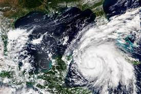
Hurricane Ian continued to strengthen as it turned toward Florida early Tuesday, with residents of coastal communities around the Tampa Bay region ordered to evacuate – urged to go even short distances to avoid the worst of the storm.
The storm intensified overnight to become a Category 3 hurricane, with maximum winds estimated at more than 115 mph at its core before it made landfall in La Coloma, south of the city of Pinar del Rio in Cuba.
The National Hurricane Center warned that life-threatening storm surges, hurricane-force winds, flash floods and mudslides were expected in western Cuba overnight and into Tuesday, urging residents to move quickly to evacuate and protect property.
Ian threatens to bring severe flooding and damaging winds to Florida’s Gulf Coast, appearing bound for landfall somewhere between Naples and the west coast’s Big Bend area between Wednesday and Thursday.
It is forecast to become a Category 4 storm with 140 mph winds by late Tuesday or early Wednesday, which would make it the strongest September hurricane in the Gulf since Rita in 2005.
Hurricane warnings were issued across the Tampa Bay region Monday evening, along with storm surge warnings.
The hurricane’s biggest threat may be the storm surge – a rise in ocean water over normally dry land caused by low air pressure and winds. The National Hurricane Center predicts Ian could send as much as 5 to 10 feet of storm surge onto Florida’s coastline, a hazard that can be deadly and destructive.
The gentle slope of the ocean bottom along the Florida coastline can mean that even a minor hurricane or tropical storm can be capable of causing serious coastal inundation.
The storm is also expected to bring flooding rains as it stalls along the coast, with 10 or more inches in some areas.
Ian comes as part of a surge of late-season tropical activity in the Atlantic basin, which saw zero named tropical cyclones form during August. While meteorologists had been watching as many as five tropical systems in recent days, including a nascent Ian, the storm is now one of two under surveillance. The other, several hundred miles west of the Cabo Verde Islands, could soon become Tropical Storm Julia.